GIS & REMOTE SENSING
Ortho Rectification
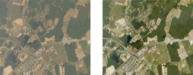
Digital satellite images and aerial photographs play an important role in general mapping, as well as GIS data acquisition and visualization. First, they help provide a solid visual effect. Many people are more able to put spatial concepts into perspective when they see photos. In addition, the secondary and perhaps more vital role is to provide a basis for gathering spatial information Before this information can be gathered in a manner that is useful for a mapping or GIS system, the satellite image data or aerial photographs must be prepared in a way that removes distortion from the image. This process is called orthorectification, also known as orthoimagery, is precisely registered to a ground coordinate system and the image scale is constant throughout the entire image
Image Classification
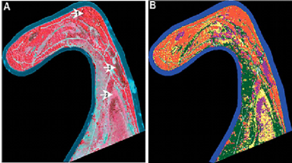
The intent of the classification process is to categorize all pixels in a digital image into one of several land cover classes, or "themes". This categorized data may then be used to produce thematic maps of the land cover present in an image. Normally, multispectral data are used to perform the classification and, indeed, the spectral pattern present within the data for each pixel is used as the numerical basis for categorization. We at VS Geospatial Technologies have successfully executed Remote sensing projects which includes Digital Image Processing Techniques for Image restoration, correction, Enhancement, Resolution Merging, as well Information extraction through Image classification.
View Shed Analysis And Land base Creation
In order to find the accurate location of installation of meters based on the geographical location, Client wanted to create a land base data where VS was asked to create or extract the land base features such as Road Edge, Road Centre Line, Building, Hydrology Features, Vegetation, Open Space Boundary mapping. Labeling Sector No, Road Name, Land Marks using satellite imagery. Attribute data like road name, locality name, building names etc was also extracted for the same data set. The same data was cleaned and was corrected topologically to be imported or used by any third party software.
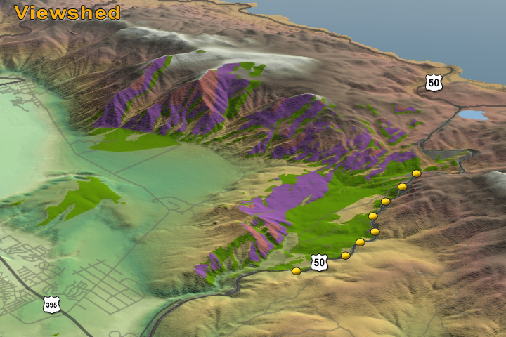
VSGT were also asked to create the DEM (Digital Elevation Module) which will give client the 3D representation of a terrain's surface of the area of Interest. DEM data was used for carrying out the View shed analysis by client. A view Shed is an area that is visible from a specific location. View Shed analyses are a common function of most GIS software. The analysis uses the elevation value of each cell of the DEM to determine visibility to or from a particular cell. The location of this particular cell varies depending on the needs of the analysis. View Shed analysis is commonly used to locate communication towers or determining the view from a road.
Thematic Map Creation
The Scope of the project was to design GIS System which will store, retrieve, manage, display and analyze all geographical features/spatial data and characteristics of the network of Bhakra Canal & Gang Canal system, its command area (down to chak/field level) and farmers. Canal networks was developed in form of nodes or points for various structures on canals including outlets, lines for channels and canal command/subcommands, Outlet command areas as polygons and maps as raster images. Suitable geo-coding for canal and canal structures, outlets and other spatial data shall be created. All technical data, maps, and drawings related to the canal system was collected from the authorities of the project, and that pertaining to command area from CAD authorities, agriculture/revenue state groundwater board offices. Canal Network Database and Mapping:-Canal Network include main, branch, distributaries and minors and water courses. Technical particulars of the canal segments and structures, including outlets were attached to specific nodes and line segments of the canal. Technical data for canals included length, NSL, bed level and width, side slope, bed slope, Mannings ‘n’ , design discharge and full supply depth/water levels, top of embankment at all key locations. Structures were identified by type, canal RD at which located, physical dimensions, and discharge rating tables in case of flow control/measuring structures. The outlets were identified by appropriate numbering to distinguish between approved and unapproved outlets and a relational database on their technical & hydraulic features, such as location and type of outlet. Its physical setting and dimensions, design discharge and CCA, FSL of parent channel and water course, and irrigated area and water users’ particulars.